
Maps of King’s Cliffe
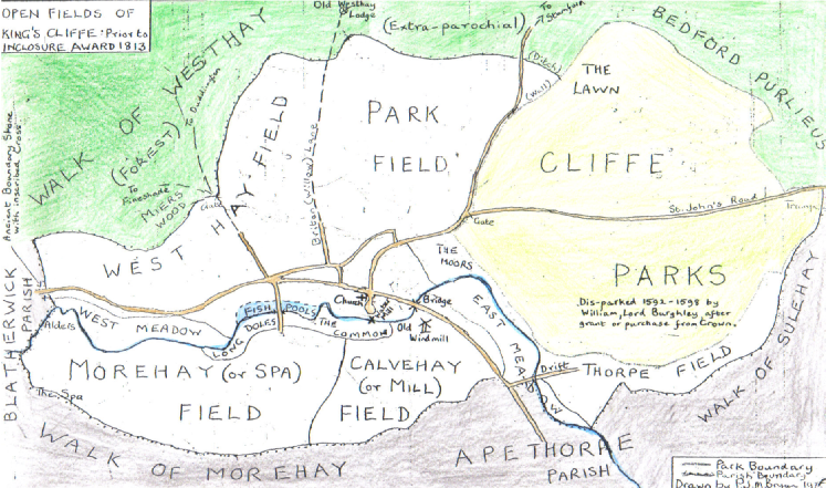
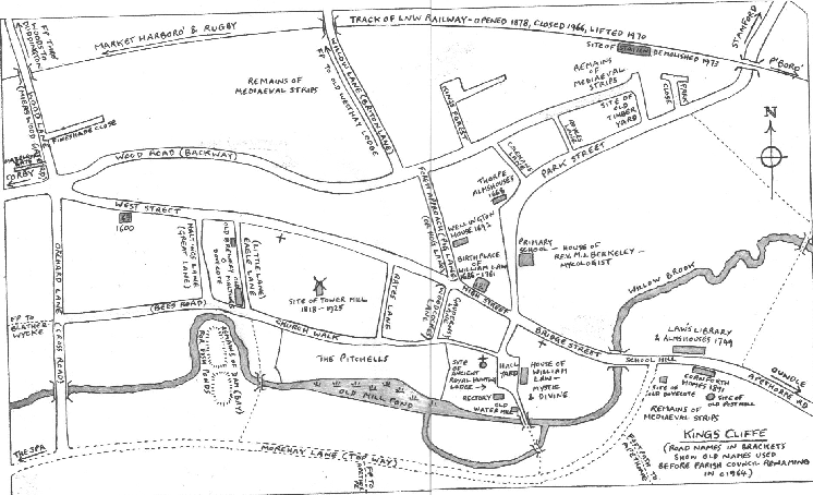
Two maps of King’s Cliffe (drawn by P. J. M. Bryan, rector, 1975), showing, above, the fields mentioned in the glebe terrier of 1729,
and, below, the streets and historic buildings of the village
(Northamptonshire Record Office, document ref: 2B 149/254)
and, below, the streets and historic buildings of the village
(Northamptonshire Record Office, document ref: 2B 149/254)
West

Of course, many other maps of King’s Cliffe exist, both modern-day and historical.
Historical Maps
Historical Maps
|
|
An excellent series of historical maps of England are the Cassini Historical Maps. Map 141 (Kettering & Corby) features King’s Cliffe and the surrounding area as it was circa 1830; Fotheringhay can be found on Map 142 (Peterborough).
|
|
|
The Northamptonshire Record Office holds a number of other maps, some of the most interesting belonging to the Marquis of Exeter’s Archives, the originals of which are kept at Burghley House.
|
|
|
The National Archives also holds some maps of the area, some of which are found within historical documents and surveys.
|
|
|
A good website from which to buy historic maps is http://www.earlymaps.com.
|
Modern-
|
|
An excellent series of leaflets about the village of King’s Cliffe can be found at the website:
|
The leaflets contain a number of local walks and each has a relevant map. They include an unprecedented range of local features.
|
|
Ordnance Survey maps are, of course, an invaluable source for any local studies. They provide probably the best means of being able to transfer information gleaned from historical maps to a present-
|
With many 17th-
Having a clear understanding of the local geography also allows us appreciate why individuals may have moved about as they did. The layout of local roads in the area around King’s Cliffe appears not to have changed greatly over the centuries. We are thus able to appreciate easily that some villages, although lying nearby, may not have been easily accessible by road.
Of course, few maps give exactly the information we would want and so it is necessary to look at a variety of sources and cross-
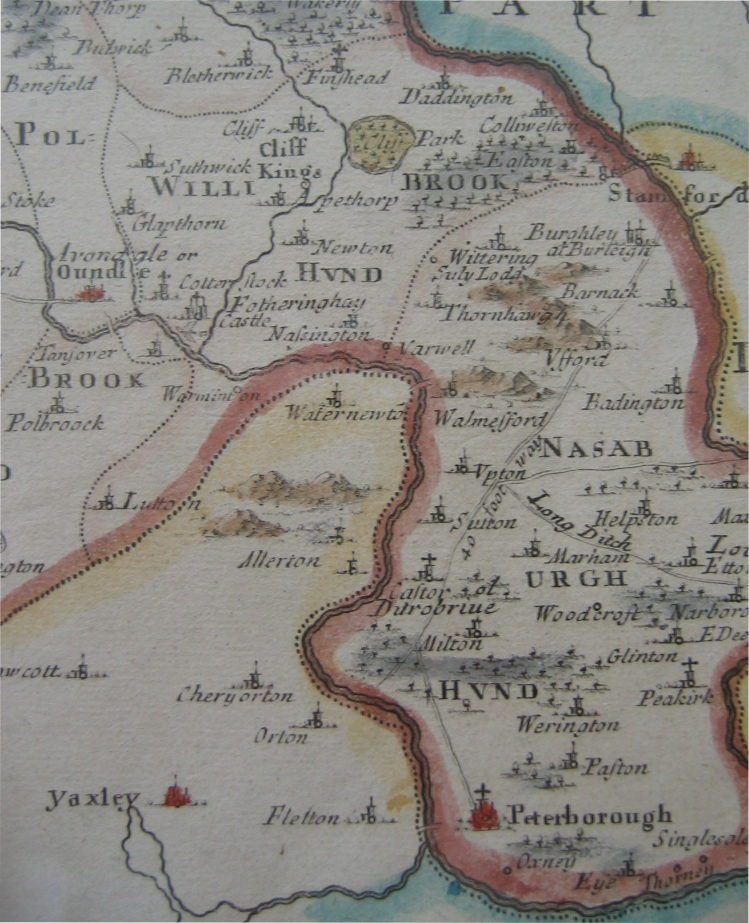
I was fortunate to find the beautiful map below for sale at the Society of Genealogists Fair at Olympia in May 2007. It was made by Robert Morden (c1650-1703) and published in 1695 in a new edition of William Camden’s Britannia, a topographical survey of England made in the Elizabethan period. Typical of its time, no obligation is felt to place north at the top!
Most of what can be seen on the map falls into Northamptonshire, with Huntingdonshire here shown below, Rutland to the right, above, and Lincolnshire to the right, below. County boundaries are shown with a red line, while hundreds (local administrative districts) are shown with dotted lines. King’s Cliffe was part of the Willybrook Hundred, named after the Willow Brook that flows through the village. It appears to be the largest village in the hundred, although not on the scale of either Oundle, in the neighbouring Polebrook Hundred, or Stamford, just across the Lincolnshire border. It is clear that an important local feature at this time was Cliffe Park.
N.B. It is not clear whether the coloured lines were an original feature of the map or if they were added later.
To Top of Page
All contents of this website © 2008 Stephen Willis
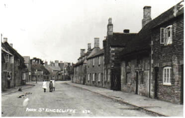
A photograph possibly from around 1900 of Park Street, looking north (taken from roughly where indicated)
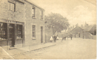
A photograph possibly from around 1900 of Park Street, looking south (taken from roughly where indicated) - the church spire is just visible


| Site Map |
| Background to my research |
| Background to the surname NEWBON |
| Documents available and sources used |
| Name index |
| Walter Newbon's descendants |
| Northamptonshire Newbons |
| Redbourn, Hertfordshire |
| James Shelton Newbon |
| Henry Newbon |
| The Crickmer family |
| The Newbon Family and the City of London |
| Charles Evans Newbon |
| Joseph Newbon |
| The Brockelbank Family |
| The United Wards' Club of the City of London |
| John Newbon |
| The Children of John Newbon |
| World War I |
| Walter Thomas Newbon |
| The Newbon Family of Northamptonshire |
| Northamptonshire, the early home of the Newbon Family |
| King's Cliffe |
| Records of King's Cliffe |
| Maps of King's Cliffe |
| Links with elsewhere |
| News 2014 |
| News 2013 |
| News 2012 |
| News 2011 |
| News 2010 |
| News 2009 |
| News 2008 |
| Updates |
| To do |
| Guestbook |